EXPLORE THE HISTORIC SANCTUARY OF MACHU PICCHU with this slideshow, check the location map and get all the facts and information below.

For slideshow description see right or scroll down (mobile). Click to view slideshow

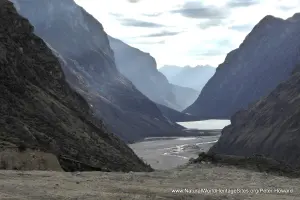
Location and Values: The Historic Sanctuary of Machu Picchu – Lost City of the Incas – is located on the eastern slopes of the Peruvian Andes, perched on a high mountain ridge overlooking the surrounding jungles. It is South America’s most iconic archaeological site, recognized across the world, and steeped in mystery following its ‘disappearance’ after the fifteenth-century Spanish conquest of Peru, and subsequent ‘re-discovery’ in 1911.
The natural attributes of this mixed site are less widely recognized, but exceptional in their own right. The archaeological ruins are embedded in a much larger protected area (383 km2), spanning a vast range of altitude and natural habitats. These include the snow-capped summit of Salcantay (6,241m) and nearby Andean peaks, descending through alpine tundra and open paramo grasslands to montane cloud forest and sub-tropical humid forests at 1,850m. The vast range of altitude combines with a diverse topography and high rainfall to create an exceptionally dynamic ecosystem in a transition zone between the high Andes and Amazonian rainforests, recognized through the site’s listing under criterion (ix) recognizing ongoing ecological processes.
Conservation Status and Prospects. According to IUCN’s Conservation Outlook Assessment (2017) the conservation status of the Historic Sanctuary of Machu Picchu is ‘of significant concern’. The IUCN report notes that ‘floods, landslides, fires and changes in temperature patterns associated with climatic variability, in addition to the growing demand for visitors, as well as the continued contamination of the Urabamba River and the vision of regional development based on tourism, continue to be serious threats to the site and its global heritage values. Although the measures taken to ensure the effective protection and management of the site have shown important progress, they still need to be strengthened to guarantee protection in the long term, especially in terms of the broader vision of conservation management of the Cusco region and its focus on tourism. ’
Links:
Google Earth
UNESCO Official Website
IUCN Conservation Outlook
UNEP-WCMC Site Description
Slideshow description

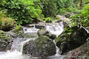
The slideshow ‘tells the story’ of the natural and cultural attributes of the Historic Sanctuary of Machu Picchu, starting with a few photos of the high Andean peaks in the far south of the protected area (kindly provided by Cesar Juanico). There are a number of trekking options available to visitors who want to see more of the site than its archaeological ruins, including the historic Inca Trail, and a longer Salcantay trek (which passes through some of the more scenic high mountain areas). Most of the photos in this series were taken on the ‘Short Inca Trail’ which starts in the Urubamba River Valley (at the 104 km railway stop), and passes through the Inca ruins of Chachabamba and Winay Wayna, along the winding path through grasslands and forests, passing the occasional waterfall. The trail reaches the Sun Gate (Intipunku) on a high vantage point overlooking the Machu Picchu complex, with spectacular views. The archaeological site is closed before sunset and overnight visitors stay at the riverside town of Aguas Calientes in the gorge below, making an early start to enter the site as the early morning mist begins to clear.
The slideshow illustrates the steep climb up Machu Picchu mountain, including some of the orchids, bromeliads, and other flora along the way, with some stunning views of the archaeological site and its natural setting. A short hike to the Inca Drawbridge passes along a cliff-side path with further views of the steep gorge below, as well as the montane forest and typical flora.
Visitors to the archaeological site follow a one-way system to avoid congestion, as they marvel at the extraordinary skill of the masons who built this monumental complex of buildings (with massive interlocking stones to withstand earthquakes). Amongst the ruins, observant visitors may catch a glimpse of a viscacha (chinchilla), or any of the 423 species of birds known from the sanctuary.
Factfile
Website Category: Mountains;
Area: 382 km2
Inscribed: 1983
Criteria:
- Outstanding natural beauty (vii);
- Ecological processes (ix);
- Cultural criteria (i,iii)