EXPLORE THE NANDA DEVI AND VALLEY OF FLOWERS NATIONAL PARKS with this slideshow, check the location map and get all the facts and information below.
For slideshow description see right or scroll down (mobile). Click to view slideshow

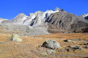
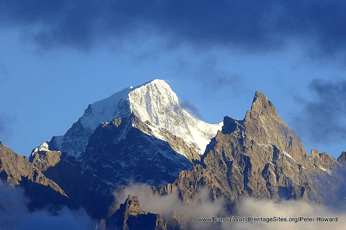
Location and Values: The Nanda Devi and Valley of Flowers National Parks are located in India’s Uttarakand province in the western Himalayas, and constitute two strictly protected areas within the broader Nanda Devi Biosphere Reserve (5,861 km2). The larger of the two areas (Nanda Devi NP, 625 km2) encompasses India’s second highest Himalayan peak (Nanda Devi, 7817 m) and a ‘ring’ of other high peaks around a spectacular ‘complex’ of glaciated valleys spilling into a deep forested gorge (the Rishi Ganga gorge). The park serves as a strictly protected ‘core area’ within the Biosphere Reserve and access has been closed since 1983, so the dramatic beauty and aesthetic qualities of its high peaks can only be appreciated from a few hiking routes in adjacent areas and along the park boundaries. The much smaller Valley of Flowers National Park (87 km2, lying about 35 km to the north) comprises a high-altitude ‘hanging’ valley renowned for its diverse alpine flora and spectacular summertime profusion of flowers. This small park attracts about 13,500 day visitors during the summer months, and no permanent infrastructure, human settlement or livestock grazing is permitted. The two parks are recognized on the world heritage list for their outstanding mountain scenery and biodiversity. The flora and fauna have not been fully assessed but are important for their diversity and rarity. At least six species of plants are recognized to be internationally threatened, while threatened large mammals include snow leopard, Asiatic black bear, Himalayan tahr and serow.
Conservation Status and Prospects. According to IUCN’s Conservation Outlook Assessment (2017) the conservation status of the Nanda Devi and Valley of Flowers National Parks is ‘good, with some concerns’. The IUCN report notes that ‘The area has been under effective management for over three decades now. However, continued vigilance is required as the area is large and terrain is difficult. The human resources for management of the site need to be augmented. The site holds significant populations of species of global conservation significance and their current state is good. The status of flora, fauna and their habitats monitored periodically through scientific expeditions indicates improvement in the population status of key wild animal and plant species. The level of current threats to the site is low; however, development of hydroelectric projects in the vicinity or in the buffer zone represents a high potential threat. Particularly, the cumulative impacts of various projects are of high concern and need to be considered during planning and approval stages of each project.
Links:
Google earth
Official UNESCO Site Details
IUCN Conservation Outlook
UNEP-WCMC Site Description
Birdlife IBA
Slideshow description

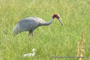
The slideshow is intended to ‘tell the story’ of the Nanda Devi and Valley of Flowers National Parks, and features a portfolio of photos from a 10-day visit by Peter Howard in September 2017. The photos are arranged chronologically and illustrate visits to three separate areas in and around the two parks. They start with the Valley of Flowers National Park, followed by a 5-day trek around the western boundary of Nanda Devi National Park, and a day trip to Auli and Gorson Top (for stunning sunset views of Nanda Devi and adjacent peaks). The approach to the Valley of Flowers involves a 4-5 hour hike along a well-made path from Govind Ghat to Ghangaria alongside trains of pack animals and masses of Sikh pilgrims making their way to Hemkund, a holy snow-melt lake in an adjacent ‘hanging valley’. Ghangaria is a small seasonal ‘service’ town nestled amongst tall conifers that is closed in mid-October for the winter. Visits to the Valley of Flowers (and Hemkund) must therefore be made in summer before the area becomes snow-bound. I had hoped that a September visit would enable clear views of the valley and its picturesque surrounding peaks (as it is often obscured in clouds and subject to torrential monsoon rains earlier in the summer, when the flowers are at their peak), but I was unlucky. The photos in the slideshow give a sense of the valley in autumnal mood, the rank herbaceous vegetation turned brown by the first frosts and the surrounding peaks shrouded in mist and swirling clouds. Amongst the mammals that may be encountered, photos of Himalayan tahr (a mountain goat), Himalayan pika (a small rodent), grey langur monkey and macaques are included here.
The 5-day trek to Nanda Devi National Park was more productive photographically, with some fine clear weather and a good display of late-flowering plants along the way. It is a tough 3-day outbound trek to reach Dharansipass via Lata Kharak, with some precipitous cliff-hanging paths to negotiate, but the far-reaching views of Nanda Devi, other glacier-flanked peaks and the deep Rishi Ganga gorge from the park boundary are simply awe-inspiring. Surrounded by wild mountains, a handful of Bharal (Himalayan blue sheep) grazing nearby and the occasional Tibetan fox traversing the scree slopes this is a true wilderness, far from civilization, where trekkers are unlikely to meet with anyone else.
The final part of the slide show provides distant views of the main peaks in this part of the western Himalayas viewed from the popular ski resort of Auli. There is a cable car between the main town of Joshimath and Auli, providing easy access to forests of golden oak and some extensive alpine meadows. With a bit of luck visitors can enjoy fine views of Nanda Devi, and other prominent peaks surrounding the park. The alpine meadows in this area (outside the park) are intensively grazed by cattle and other livestock, providing an interesting ecological comparison with areas within the parks where livestock is excluded.
Factfile
Website Category: Mountains
Area: 718 km2
Inscribed: 1988 (VoF extension 2005)
Criteria:
- Outstanding natural beauty (vii);
- Natural habitat for biodiversity (x);
- Significant number of rare, endemic and/or endangered species (x)