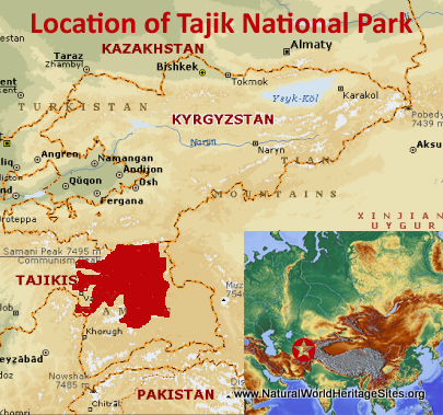
EXPLORE Tajik National Park (Mountains of the Pamirs) with this slideshow, check the location map and get all the facts and information below.
For slideshow description see right or scroll down (mobile). Click to view slideshow
Location and Values: Tajik National Park (Mountains of the Pamirs) covers a vast expanse of spectacular glaciated mountains, high alpine desert and lakes lying at the centre of the so-called ‘Pamir Knot’, a meeting point of the highest mountain ranges on the Eurasian continent. The Pamir (meaning ‘Roof of the World’ in Farsi) is the third highest mountain range in the world (after the Himalaya and Karakoram mountains), with several peaks above 7,000m including the highest (Peak Somoni) at 7,495m. It lies in one of the most tectonically active regions of the world where the enormous tectonic forces arising from the collision of the Indian-Australian Plate and the Eurasian Plate have thrown up the high mountain ranges that radiate out in all directions from the Pamir Mountains.
The area is recognized on the world heritage list for its outstanding value to our understanding of earth building processes, plate tectonics and subduction phenomena. These processes have given rise to some exceptional natural phenomena, notably (1) the creation of a very high, deep lake (Lake Sarez) impounded a century ago by a severe earthquake that resulted in a massive landslide that filled a valley and created a huge natural dam, and (2) the world’s longest glacier outside the Polar regions (Fedchenko Glacier). Another lake within the site (Lake Karakal) is reckoned to be the world’s highest large lake created from a meteor impact.
Conservation Status and Prospects. According to IUCN’s Conservation Outlook Assessment (2020) the conservation status of the Tajik National Park (Mountains of the Pamirs) is ‘good’. The IUCN report notes that the large size, alpine wilderness character and low resident population ensure that threats from human activities are minor and localized. The main potential threat is climate change which is contributing to the rapid melting of glaciers and may alter the ecological character of the site in the long term. Of more immediate concern is the harvesting of the slow-growing teresken plant for household fuel, as this is leading to denudation of wide areas in the fragile semi-desert environment. Livestock grazing and local community use of natural resources is permitted in designated zones, but there is a risk that this could exceed the limits of sustainable use.
Links:
Google Earth
Official UNESCO Site Details
IUCN Conservation Outlook
UNEP-WCMC Site Description
Birdlife IBA
Slideshow description
The slideshow ‘tells the story’ of the spectacular Tajik National Park (Mountains of the Pamirs). It starts with views of scenic Lake Karakal (the product of a massive meteor impact), followed by a couple of aerial views of the broader Pamir Mountains landscape and pictures of Lake Sarez (showing the scars of the massive landslide and natural dam that created it).
The park’s fauna is relatively poor, but some of its more iconic species are illustrated, including snow leopard, the endemic Marco Polo argali sheep, long-tailed marmot, Himalayan brown bear and Siberian ibex. The slideshow includes a series of photos from a road route through the steep-sided valleys and high alpine deserts around the periphery of the site, starting in the southwest, along the southern boundary and northwards along its eastern flanks. This gives an excellent general overview of the landscapes in the lower-lying parts of the park and is followed by a series of photos of a mountaineering ascent of the park’s second highest peak, Ibn Sina (also known as Lenin Peak, 7,134m). The ascent passes some massive glaciers and icefields and can only be attempted by fully equipped mountaineering teams.
The following Flickr photographers and other sources are acknowledged with thanks for their contributions to this slideshow: Cloudtail the Snowleopard, allanv, flavijus, Kate Dixon, ninara, Snowleopard Lodge Ladakh, twiga269-FEMEN, US-Embassy-Pakistan, Antoine49, Michael Wong, David Stanley, Georg Sander and David Ells.
Factfile
Website Categories:
Mountains;
Earth Features
Area: 26,117 km2
Inscribed: 2013
UNESCO Criteria:
- Exceptional natural phenomenon (vii);
- Outstanding natural beauty (vii);
- Geological features (viii);


