EXPLORE Donana National Park with this slideshow, check the location map and get all the facts and information below.

For slideshow description see right or scroll down (mobile). Click to view slideshow

Location and Values: Donana National Park is one of Europe’s most extensive wetlands, located at the mouth of the Guadalquiver River on the Atlantic coast in the south of Spain. Its complex of swamps, marshes and mudflats is especially important as an overwintering site for wetland birds, and a stopover for many species that use its habitats on passage to sites further south, in West Africa. In addition to its extensive wetlands, the park includes a diversity of other habitats, including coastal dunes, dry Mediterranean scrub (known as maquis) and forests of stone pine and cork oak. These habitats support an abundant fauna, with large populations of species such as rabbits, fallow deer, mongoose and spur-thighed tortoises. These in turn support a number of important predators, including one of Europe’s last remaining populations of Iberian lynx (probably about 30 individuals), and 8-13 breeding pairs of Spanish Imperial eagles.
Conservation Status and Prospects. According to IUCN’s Conservation Outlook Assessment (2017) the conservation status of the Donana National Park is of ‘significant concern’. The IUCN report notes that Doñana National Park is threatened by a continuing reduction in the quantity and quality of water supplying the natural wetlands, with knock-on effects on alien invasive species and wildfires. Park managers are severely constrained in their efforts to maintain the world heritage values of the site by water extraction and other threats originating outside the park boundaries, beyond the park’s jurisdiction. Some initiatives, for example a decision against dredging the Guadalquivir River and the development of a ‘Special Management Plan for the Irrigation Zones located to the North of the Forest Crown of Doñana’ have been very positive but a lot more needs to be done if the outstanding values of Donana National Park are going to be successfully restored and sustained.
Links:
Google Earth
UNESCO Official Website
IUCN Conservation Outlook
UNEP-WCMC Site Description
Birdlife IBA
Slideshow description

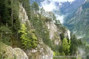
The slideshow introduces Donana National Park with a portfolio of photos by Peter Howard from a visit in June 2019. Most of the park is closed to visitors, so the photos illustrate features of the adjacent ‘natural parks’ where visitor facilities are provided and the wider landscape in which the park is located. Public access to the park is only permitted along the beach, or through participation in two guided tours. One of these is a 4-hour excursion by 4-wheel drive 25-seater bus along the beach and back through the dunes, skirting the southern edge of the marshes, while the other involves a boat trip along the main channel of the Guadalquiver River, which serves as the eastern boundary of the park. Neither of these tours offers the opportunity to see the core area of the park, or the main body of wetlands on which its world heritage listing is based.
The slideshow starts with views into the wetlands from the park fenceline, south of the small town of El Rocio. A busy main road here serves as the western boundary of the park, with two natural parks lying to the west of the road. One of these, at Acebuche, is connected to the national park via an overhead ‘wildlife bridge’ (shown in the slideshow), but habitat connectivity between the world heritage site and adjacent natural parks is otherwise rather limited as the road is securely fenced. The next part of the slideshow illustrates the coastal and dune formations that mark the long stretch of beach along the park’s southern boundary from the coastal resort town of Matalascanas. Back-tracking along the western boundary, the tour passes through the intensively cultivated lands to the north of the park, where extensive irrigated agriculture, canals and pumping stations are prominent features. The presence of so much water-dependent agricultural activity so close to the park boundary raises doubts over the impact of upstream and ground-water use on the long-term maintenance of world heritage values in the Donana wetlands.
The Centro de Visitantes Jose Antonio Valverde is located on the northern boundary of the park, and provides one of the best opportunities to see congregations of wetland birds. From here the slideshow tour returns to the western side of the park, stopping at the Acebuche Visitor Centre with its boardwalk trails, and numerous birdwatching hides strategically positioned along the wetland margins of the ‘natural park’ (unfortunately rather short on water and birds at this time of year!). Here efforts are underway to restore the naturally-occurring Mediterranean scrub vegetation, removing the planted Stone Pines that dominate much of the landscape. The slideshow continues with a visit to La Rocina visitor centre and adjacent areas, taking in the Palacio del Acebron, and finishing with some photos of El Rocio town. The town sits on the edge of the park, and a wide esplanade, studded with binoculars enables visitors to see some of the flamingos, geese, ducks and wading birds that use the shallow waters, mudflats and flooded grasslands here.
Factfile
Website Categories: Lakes, Freshwater Wetlands & Glaciers;
Area: 543 km2
Inscribed: 1994 (extended 2005)
Criteria:
- Outstanding natural beauty (vii);
- Ecological processes (ix);
- Natural habitat for biodiversity (x);
- Significant number of rare, endemic and/or endangered species (x)