EXPLORE the French Austral Lands and Seas with this slideshow, check the location map and get all the facts and information below.

For slideshow description see right or scroll down (mobile). Click to view slideshow

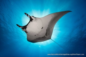
Location and Values: The French Austral Lands and Seas is the largest site on the world heritage list, spread between three serial components in the Southern Ocean at latitudes of 37-50oS. It is about twice the size of the Great Barrier Reef world heritage site and similar in extent to the entire area of France or the US state of Texas. The three components each include an archipelago of pristine volcanic islands and their surrounding seas, making up a total land area of 7,669 km2 (1.1% of the site) with 665,301 km2 of seas (98.9%). The islands have large continental shelves and lie at the convergence of three ocean fronts, creating highly productive marine environments in the middle of a relatively poor ocean. They are home to over 50 million birds, including the world’s largest populations of King Penguin and Yellow-nosed albatross, as well as vast numbers of marine mammals including the second-largest population of elephant seals. The very remote location of the islands, thousands of kilometers from the nearest continental land mass, has protected them from human activity and provides a unique opportunity for the study of ongoing processes in biological evolution and the impacts of climate change.
Conservation Status and Prospects. According to IUCN’s Conservation Outlook Assessment (2020) the conservation status of the French Austral Lands and Seas is ‘good’. The islands are uninhabited (except for three small scientific/military bases) and visitation is minimal. The impacts of past exploitation of whales, penguins, seals and lobsters have now been largely restored. However, there remain significant threats from invasive alien species, including rats, mice, rabbits, cats and reindeer as well as some invertebrates and introduced plants, such as dandelions and some grasses. The longer-term impacts of climate change remain unknown but potentially severe. Illegal, Unreported and Unregulated (IUU) fishing remains a problem across such a wide swath of remote seas with minimal surveillance capacity.
Links:
Google Earth
Official UNESCO Site Details
IUCN Conservation Outlook
Birdlife IBA
Slideshow description

The slideshow ‘tells the story’ of the French Austral Lands and Seas with a portfolio of photos to illustrate to landscapes and wildlife on each of the main island groups. It starts with the smallest of the island groups with photos of Amsterdam and Saint Paul Islands (the most northerly group, which lie in the cool temperate zone), followed by the Crozet Archipelago before finally showing the larger, glaciated and highly dissected Kerguelen island with its associated smaller islands. The principal species of birds and marine mammals are shown, including king penguin colonies, elephant seals, sub-Antarctic fur seals, various species of albatross, killer whales and the endemic Commerson’s dolphin (around Kerguelen).
The following Flickr photographers and other sources are acknowledged with thanks for their contributions to this slideshow: Communication-TAAF, Jeremy-Tornos, Xavier-Desmier and Pascal-Subtil.
Factfile
Website Categories:
Marine & Coastal;
Islands
Area: 672,969 km2
Inscribed: 2019
UNESCO Criteria:
- Exceptional natural phenomenon (vii);
- Ecological processes (ix);
- Natural habitat for biodiversity (x);