EXPLORE the Putorana Plateau with this slideshow, check the location map and get all the facts and information below.

For slideshow description see right or scroll down (mobile). Click to view slideshow

Location and Values: The Putorana Plateau lies within the Arctic Circle in northern Siberia, coinciding with the boundaries of the Putoransky Zapovednik (State Nature Reserve, a strictly protected category). It is a scenically-spectacular highland dome of basaltic trappe (rock steps) derived from vast volcanic lava flows, at elevations of 800 – 1,000m. This ancient rock dome has been dissected by deep canyons, with thousands of waterfalls and river valleys carved by glaciation to create long lakes. It is a vast expanse of pristine wilderness at the interface between northern taiga forest and Arctic tundra. The area experiences a range of humid and dry climates resulting in an unusually rich flora (for an area within the Arctic Circle) with carpets of lichen, pockets of forest and high Arctic desert. The plateau serves as one of the world’s great bird migration routes, the Central Asian flyway, and supports the world’s biggest population of wild reindeer (500,000 animals) which spend 5-6 months here during their migration.
Conservation Status and Prospects. According to IUCN’s Conservation Outlook Assessment (2020) the conservation status of the Putorana Plateau is ‘good’. The IUCN report notes that there have been recent changes in the legal framework for protected areas in the Russian Federation, which might increase the level of potential threats to the site, despite its present remote wilderness character. The report expresses concern over the potentially damaging impacts of mining, tourism development and commercial hunting of Putorana snow sheep if these are allowed in future. Climate change is a further pressure that is likely to have ecological impacts in the future, although the nature of this is not yet understood.
Links:
Google Earth
Official UNESCO Site Details
IUCN Conservation Outlook
UNEP-WCMC Site Description
Slideshow description

The slideshow ‘tells the story’ of the Putorana Plateau with a portfolio of photos that illustrate the diversity of landscape features, vegetation and some of the typical wildlife. The southern portion of the plateau is covered by taiga forests which penetrate north along river valleys as shown at the start of the slideshow. A feature of the plateau’s location within the Arctic Circle is the appearance of the Aurora borealis, a spectacular night-time light display resulting from disturbance in the magnetosphere caused by solar wind. At this latitude the polar day (with 24 hours of daylight) last 53 days during summer and the polar night (with perpetual darkness) 31 days through most of December into January. Hence all the photos in the slideshow illustrate the site during the summer months when most of the snow has cleared and waterfalls are ice-free.
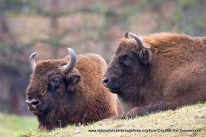
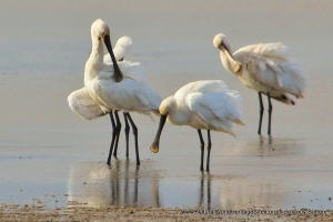
Amongst the birds and mammals, photos of capercaillie, white-tailed eagle, bar-headed and red-breasted geese are included, as well as a couple of images of reindeer and the Putorana snow sheep (an endemic sub-species). The State Nature Reserve (Zapovednik) has no roads and is only accessible by helicopter or boat; a strict protection regime is in place, with only scientific research and monitoring allowed. However, this strictly protected area is embedded within a wider buffer zone, where fishing and hiking are allowed, and some very large fish can be landed from the cold water lakes and rivers!
The following Flickr photographers and other sources are acknowledged with thanks for their contributions to this slideshow: Imran-Shah, Terje-Asphaug, Alex-Goliakov, Andrey-K, Dmitry-Nazarov, Eugene-Morozov, luck-o-matic, m_hkimmel, Viewjom2, Yury-Meklin, Sergey-Gorshkov-naturepl, Kentish-Plumber, dration, Sergey-Yeliseev, Smudge-9000 and Nancy-O.
Factfile
Website Categories:
Lakes, Freshwater Wetlands & Glaciers;
Temperate & Boreal Forests;
Temperate Grasslands, Steppes, Shrub-Lands & Tundra
Area: 18,873 km2
Inscribed: 2010
UNESCO Criteria:
- Exceptional natural phenomenon (vii);
- Outstanding natural beauty (vii);
- Ecological processes (ix);